 Official Site of The State of New Jersey
Metadata Support
  |
What are metadata?
Metadata are structured "data about data." High-level (i.e. overview) geospatial metadata about data sets are similar to library catalog records about books, but contain more information. The structure of the metadata is determined by a named standard to enable interoperability.
Why metadata?
Metadata are essential for use and re-use of data. Geospatial metadata explain the contents of the data, how and why the data were created, the geographic location of the data, and how the data can be acquired and used.
Why write full metadata?
- To enable potential users (including the data creator, after time marches on) to understand the data set and its quality in detail, and assess its fitness for the use intended.
- To satisfy State of New Jersey spatial data delivery requirements for vendors.
- To protect creators and distributors when sharing data. A structured geospatial metadata record may be used to specify responsibility and to disclaim it.
- Full Federal Geographic Data Committee’s Content Standard for Digital Geospatial Metadata (FGDC - CSDGM) metadata is considered best practice and is the State of NJ standard for metadata.
Metadata requirements for sharing your data with NJGIN Open Data
- Metadata in ArcGIS format, FGDC - CSDGM style
- Correct and current entries for a small subset of elements, called NJGIN Core
- Metadata incorporated into the ArcGIS Online item (see Share Your Data for details)
What metadata standard does NJGIN Open Data use?
NJGIN Open Data, hosted on ArcGIS Online Hub, uses the FGDC - CSDGM Style ArcGIS metadata. Eventually it will transition to International Organization for Standardization (ISO) 19115 Style ArcGIS metadata.
What metadata editor should I use?
Here is guidance for choosing a metadata editor for ArcGIS metadata.
Use the ArcGIS Online metadata editor to write and update ArcGIS format, FGDC - CSDGM style metadata. This option is good for those who are new to writing metadata and who want to use a simple interface. Learn how to enable metadata in your ArcGIS Online organization here.
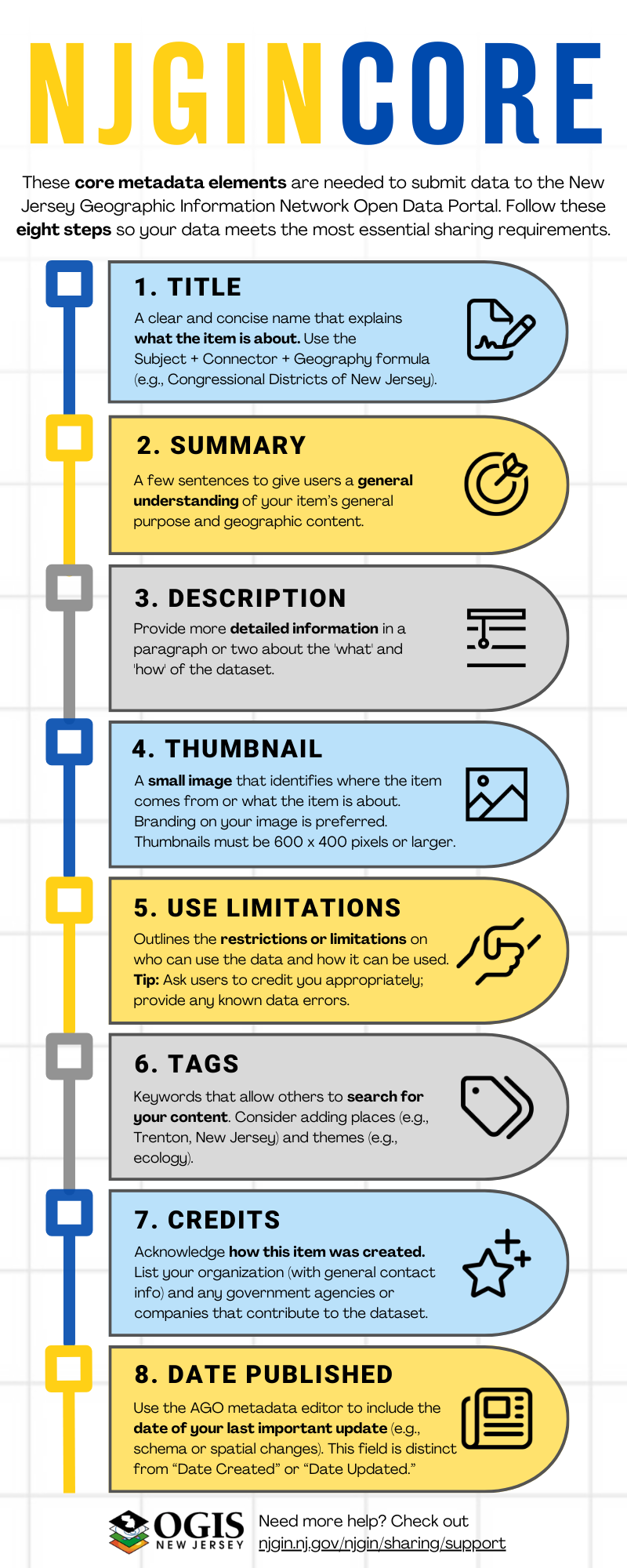
NJGIN Core for ArcGIS Online Metadata Editor
NJOGIS has developed the following abbreviated collection of required metadata elements to support search and facilitate publishing on NJGIN Open Data, called NJGIN Core:
NJGIN Core Infographic
NJGIN Core Instructional Video
Use the ArcGIS Pro metadata editor to write and update ArcGIS format, FGDC-CSDGM style metadata. This option is good for ArcGIS Pro users, especially those who plan to publish hosted layers using ArcGIS Pro.
NJGIN Core for ArcGIS Pro Metadata Editor
NJOGIS has developed the following abbreviated collection of required metadata elements to support search and facilitate publishing on NJGIN Open Data, called NJGIN Core:
NJGIN Core Infographic
NJGIN Core Instructional Video
Writing Full Metadata using ArcGIS Pro Metadata Editor
Create standard-compliant metadata that fully document the data, from scratch, using the ArcGIS Pro metadata editor. This option is good for those who want to use ArcGIS Pro tools to write and maintain metadata.
Authoring Full ArcGIS Metadata for ArcGIS Online, FGDC Style, From Scratch
ArcGIS Metadata Required Elements Lists for NJGIN Core and Full Metadata
If you have an old metadata record created in ArcCatalog, chances are that it is stored in in FGDC - CSDGM XML file format. You will need to upgrade your document to the ArcGIS XML format. NJOGIS has authored the following document providing some guidance on this process.
Transitioning from FGDC - CSDGM Metadata to ArcGIS Format, FGDC - CSDGM Style Metadata
Create standard-compliant metadata that fully document the data, from scratch, using the ArcCatalog metadata editor. This option is good for those who want to use ArcGIS Desktop tools to write and maintain metadata.
Authoring Full ArcGIS Metadata for ArcGIS Online, FGDC Style, From Scratch
ArcGIS Metadata Required Elements Lists for NJGIN Core and Full Metadata
If you have an old metadata record created in ArcCatalog, chances are that it is stored in in FGDC - CSDGM XML file format. You will need to upgrade your document to the ArcGIS XML format. NJOGIS has authored the following document providing some guidance on this process.
Transitioning from FGDC - CSDGM Metadata to ArcGIS Format, FGDC - CSDGM Style Metadata
Geospatial Metadata Standards
FGDC - CSDGM Standards Workbook
ISO 19115 Metadata Workbook
FGDC Metadata Page
US Geological Survey (USGS) Metadata Page
USGS Formal Metadata: Information and Software
FGDC - CSDGM vs. ISO 19115 with guidance for ArcCatalog metadata
FGDC - CSDGM Standard Full Documentation Element List
Information Gathering for Metadata
Minimal Metadata for Incident GIS
Twenty Questions about Geospatial Data for Full Metadata
Geospatial Metadata Tools
ArcGIS Desktop
ArcCatalog Metadata Editor Help
ArcGIS Online Metadata Editor Help
ArcGIS Pro Metadata Editor Help
Free Geospatial Metadata Editors
USGS Metadata Wizard
US Environmental Protection Agency (EPA) Metadata Editor
USGS FGDC - CSDGM Metadata Validation Service
Alaska Data Integration Working Group (ADIwg) mdEditor
Additional ADIwg Metadata Tools
FGDC-CSDGM Required Documentation Element List (for use with free editors)
Human Help
Feel free to Contact Us, we are happy to help!